
Fluvial Process, Oceans and Coastlines
Honduras has both a Pacific and Atlantic coastline. The largest being the Atlantic, with a length of Honduras's Atlantic coastline is approximately 430 miles long
“Mangrove ecosystems in Honduras provide key habitat for many marine and terrestrial species on both coasts. While the precise extent of seagrass is unknown in the country, mangroves and seagrass in Honduras not only function to mitigate global climate change impacts by sequestering and storing carbon in their plant structures and soils, they also provide essential climate adaptation and resilience benefits to the country’s inhabitants by protecting and stabilizing shorelines.”
-Kate Meyer, “Along Honduras’ Coasts, a Key to Conservation Success” Pew Research Center
Flooding

Honduras experiences severe flooding. Hurricanes like Hurricane Mitch and Hurricane Eta have affected hundreds of thousands of people. The government of Honduras Disaster response department COPECO has installed river monitoring devices as early warning system and collaborates with Multi-national organizations like CEPREDENAC, a regional governmental organization that promotes disaster prevention policies and good practices in Central America and the` Dominican Republic
Flooding from Hurricaine Iota

“Honduras is among the top countries worldwide affected by climate change. The northwestern region of the country, including areas like Santa Bárbara, is one of the most impacted zones. This area faces severe meteorological phenomena, including increasingly strong tropical cyclones each year. The effects of climate change have led to more frequent and intense storms, with tremendous destructive potential.”
-Luis Enrique Posadas, Deputy Director of COPECO, the Honduran government agency with responsibility for disaster response
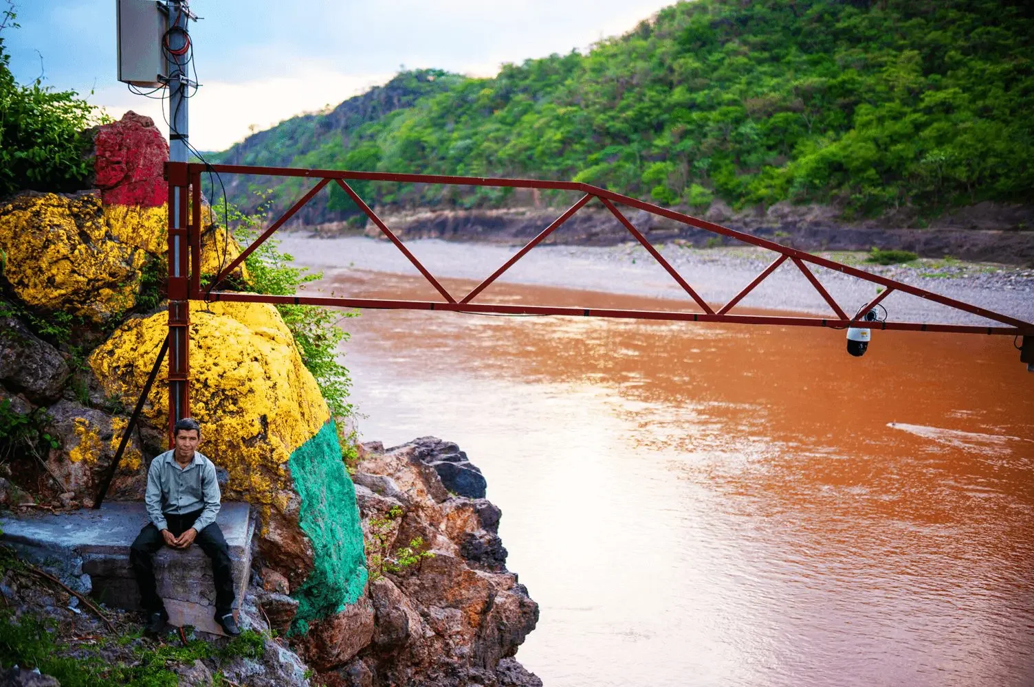
Gustavo Adolfo Ayala, 53, town leader, land local community coordinator in the region of Santa Barbara, Honduras, sits beside river level monitoring equipment. The traffic light system indicates the level of alarm for flooding. Photo: Santiago Billy/Trócaire.
Oceans, Ocean Trade Routes & Islands:
Honduras trades through it’s ports Puerto Cortés, the largest deep-water port in Central America, Puerto Castilla, San Lorenzo on the Pacific coast, Tela, and La Ceiba.
There are no active river trade routes in Honduras.
The Bay Islands ports are used primarily for tourism. Roatan, Utila, and Guanaja are all popular tourist destination and produce seafood exports like shrimp. They are home to the Garifuna people.

Honduras trades with Guatemala by land via borders like Agua Caliente, El Florido, and Corinto.
Sources
WorldAtlas. (n.d.). Which countries have coastlines on both the Atlantic and the Pacific Oceans?https://www.worldatlas.com/articles/which-countries-have-coastlines-on-both-the-atlantic-and-the-pacific-oceans.html
Pew Charitable Trusts. (2024, November 25). Along Honduras’ coasts, a key to conservation success. https://www.pew.org/en/research-and-analysis/articles/2024/11/25/along-honduras-coasts-a-key-to-conservation-success
Al Jazeera. (2020, November 6). Central America still on high alert as Hurricane Eta kills dozens. https://www.aljazeera.com/news/2020/11/6/central-america-still-on-high-alert-as-hurricane-eta-kills-dozens
Trócaire. (n.d.). Preparing for the flood: Working together to reduce risk in Guatemala and Honduras. https://www.trocaire.org/news/preparing-for-the-flood-working-together-to-reduce-risk-in-guatemala-and-honduras/
Observatory of Economic Complexity. (n.d.). Honduras (HND) exports, imports, and trade partners. OEC. https://oec.world/en/profile/country/hnd
RedHonduras. (n.d.). Customs union Honduras-Guatemala. https://redhonduras.com/en/economy/customs-union-honduras-guatemala/