
Weathering, Mass Wasting, and Erosion
Mass wasting is a large problem in Honduras. Normal counter measures like terraces are extremely labor intensive and require frequent upkeep. Honduras is the second most affected country by climate changes and experiences heavy flooding and many landlsides.
DEFORESTATION
Deforestation reduces the soils ability to absorb water. In October 2025, There were a reported 15 fatalities and a total of 29,000 people displaced by landslides. Around 2,000 homes were damaged. Authorities declared a state of emergency for the departments of Francisco Morazán, La Paz, Intibucá, and Lempira, as well as the capital district.


The Government of Honduras has begun to install early warning systems to protect against flooding and landslides across the country in partnership with NGOs such as GOAL, the Munich Re Foundation and with the UN Office for Disaster Risk Reduction
Deforestation is large and complex problem. Agriculture has cause over 50% of Honduras’s natural forests to be cut down to make space for agriculture, mainly cattle ranching. The FAO estimated the total area deforested in Honduras at 6.36 million hectares in 2020, from a total land area of 11.19 million hectares.
In 1998, Hurricane Mitch triggered landslides and flooding that killed over 9000 and displaced 3,000,000.
Rivers
The Choluteca River ravaged the capital of Honduras during Hurricane Mitch in 1998. when 75 inches of rain swelled it’s banks to 6x higher than normal, it permanently changed it’s course and washed away several villages, forever altering the landscape.
Length 349 km (217 mi)
Basin size7,681 km2 (2,966 sq mi)
Source: Choluteca
Outlet: Culf of Fonseca

Coco River
Source: Somoto Canyon
Mouth: Mosquita, Carribean coast

This river forms the border between Honduras and neighboring country Nicaragua
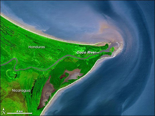
Length: 841 km (523 mi)
Basin size: 27,000 km2 (10,000 sq mi)
Deserts and Glaciers
Honduras does not have any deserts or glaciers in it’s borders. It is a tropical climate with rainforests and savannahs, as well as cloud forests.
University of New Mexico. (n.d.). *Water Resources Professional Project Reports*. UNM Digital Repository. Retrieved November 22, 2025, from https://digitalrepository.unm.edu/wr_sp/7
Dahl, M. H. (2025, April 9). *Honduras pays the climate cost as its forests disappear and storms rise*. Mongabay. https://news.mongabay.com/2025/04/honduras-pays-the-climate-cost-as-its-forests-disappear-and-storms-rise
PrepareCenter. (2022, May 18). *Sustainable land management approaches have protected communities in Honduras from landslides*. https://preparecenter.org/story/sustainable-land-management-approaches-have-protected-communities-in-honduras-from-landslides
One Tree Planted. (n.d.). *Honduras*. One Tree Planted. Retrieved November 22, 2025, from https://onetreeplanted.org/products/honduras
FLEGT IMM. (n.d.). *Honduras – forest resources*. Retrieved November 22, 2025, from https://flegtimm.eu/country-profiles/honduras/#:~:text=Forest%20Resources&text=FAO%20estimated%20the%20total%20forest,highest%20rate%20in%20the%20Americas
Author(s) Maynor Ruiz-Álvarez a, Daniel Cruz b, Adolfo Quesada-Román . (July 2025). Journal of South American Earth Sciences Volume 160, July 2025, 105555 Landslide susceptibility mapping of Tegucigalpa, Honduras. https://www.sciencedirect.com/science/article/abs/pii/S0895981125002172
Global Forest Watch. (n.d.). *Honduras country dashboard*. Retrieved November 22, 2025, from https://www.globalforestwatch.org/dashboards/country/HND
UN OCHA, COPECO, NOAA CPC. (2025, October 20). *Honduras floods and landslides: ECHO daily flash*. ReliefWeb. https://reliefweb.int/report/honduras/honduras-floods-and-landslides-un-ocha-copeco-noaa-cpc-echo-daily-flash-20-october-2025
Food and Agriculture Organization. (n.d.). *Water resources – Honduras* (Aquastat factsheet). Retrieved November 22, 2025, from https://storage.googleapis.com/fao-aquastat.appspot.com/countries_regions/factsheets/water_resources/en/HND-WRS.pdf
National Aeronautics and Space Administration. (n.d.). *The Mosquito Coast*. NASA Earth Observatory. Retrieved November 22, 2025, from https://www.earthobservatory.nasa.gov/images/6426/the-mosquito-coastaw
LACGeo. (n.d.). *Coco River, Nicaragua–Honduras*. Retrieved November 22, 2025, from https://lacgeo.com/coco-river-nicaragua-honduras
Re Munich Foundation, retrieved November 22, 2025, from https://www.munichre-foundation.org/en/climate-adaptation/goal-honduras.html